

Bushfire Australia will examine the recurrence of bushfire imagery in the work of Australian artists. The exhibition will draw on works from state, public and private collections, including Australian historical paintings and new works made in direct response to the 2009 fires, creating a reflective, poignant and ultimately hopeful exploration of this dramatic Australian phenomenon.
In this design study we took as our starting point design issues raised by the recent Victorian bushfires, from a personal to a regional scale. We considered this tragedy as a catalyst for broadly re-thinking the limitations and possibilities of community life within such bush environments on the fringes of our cities. The communities of Kinglake, Flowerdale, Healesville, Yarra Glen and others in Melbourne’s north-east are neither truly rural nor urban, but exist in an overlap zone of low-density peri-urban settlement, physically detached from, but still reliant on the metropolis for jobs and services.
We researched contemporary and historical physical manifestations of this type of ‘peripheral living’ both in Australia and around the world, while considering the liberties, restrictions and possible future directions for life on the edge of the city. Design projects ranged from landscape interventions on the scale of a township to architectural strategies for individual properties and structures.
Excerpt from studio brief , July 2009
Nigel Bertram & Gretchen Wilkins
RMIT Architecture Urban Architecture Laboratory
‘The Black Saturday bushfires wreaked most of their damage in the north-eastern hinterland of Melbourne’s greater metropolitan area. The advent of the fires drew attention to a region that is intertwined with but also in many ways outside the culture of the city. The communities of Kinglake, St Andrews, Flowerdale, Healesville, Yarra Glen, Marysville and others in Melbourne’s north-east are neither truly rural nor urban, but exist in an overlap zone of low-density peri-urban settlement, physically detached from and culturally distinct from the city, but still reliant on the metropolis for jobs, services and visitors.
The affected region plays a number of roles on a regional and urban scale. The north-east ranges are Melbourne’s primary water catchment, with their high rainfall and dramatic topography providing many weekend tourism destinations, alternative lifestyle options, and fundamental water infrastructure supporting the lives of millions. As such, the forests, watercourses and other infrastructure of the region are important not only to local communities but crucial to the functioning of the city as a whole – a point made clear by the recent political and land/ water-rights controversy of the Sugarloaf pipeline.
The work started with a series of questions, galvanised by the tragedy of the fires: What is the periphery? On whose terms? What does the annual cycle of fire-danger mean in terms of sustainable (endurable) living in such places? How can we plan better and more strategically understand our inextricable relationships with each other and with the city as a whole? How could we broadly re-think the limitations and possibilities of real community life on the fringes of our cities within such bush environments?
As architects and landscape architects, our field of research is always connected to the physical: where should we build? How should we plan? How can we live spatially together? How can we both move-with and respectfully-control this wonderful and powerful landscape, which has the ability to both entrance and destroy us? How can we think in a contemporary way about community interaction, the sustainable provision of services, and shared life in a region of low density and sparse, scattered settlement?
Research started by looking at what exists: how land has been used and settled in this area over time, the types of infrastructures and landscapes (formal and informal) that have developed to support private and community life. In this case we were also literally looking at what remained after the fires: scarred bushland, concrete floor slabs and remnant infrastructure, emergency housing around football ovals, temporary buildings and makeshift town centres; all imbued with a strong sense of community resilience.
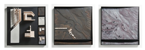
Ultimately this work was about rethinking the role of the rural periphery and its relation back to the city, from a personal to a regional scale. Master of Architecture research students in the Urban Architecture Laboratory developed particular design responces that ranged from landscape interventions on the scale of a township to architectural strategies for individual properties and structures.
Rutger Pasman proposes re-grouping and strategically connecting neighbouring properties to better work together in times of emergency. A careful analysis of existing landscape and settlement practices in the area around St Andrews allows a series of small but focussed interventions to change the way this scattered community relates and grows over time. This proposal raises the potential for shared emergency infrastructure to double as small-scale accommodation and recreational facilities in non-fire times.
Viet Tuan Pham explores intensifying and making more strategic the use of existing community facilities clustered around football ovals in small towns – and considering these as a network of support centres throughout the region. The existing public space is augmented by a range of adaptable programmes and structures, enabling different events to take place during emergency, transitional and permanent phases of living.
Simon Venturi develops a housing model on the edge of existing farms, utilising the farm’s existing infrastructure (dams and sheds) as community collection points in emergency situations, and connecting new residents to the local knowledge of the farmer. This model is based on the co-existence of residential and productive uses of land, seeing new development as potentially contributing to the endurance of other land uses, in a mutually-dependent relationship.
Lan Tian takes a landscape systems approach and maps the water infrastructure around the region of Healesville. An alternative water collection and distribution system is proposed which links landscape and infrastructure to community space, also considering the potential for shared resources on the scale of residential development.
This design research project was undertaken in the second half of 2009 by Master of Architecture by Research candidates within the Urban Architecture Laboratory research unit, in conjunction with Architecture and Landscape Architecture professional degree students at RMIT University. We would like to thank all students for their many insights, and for their commitment to contributing in some way in the wake of the tragic events of February 2009.’
Peripheral Living Exhibition Pamphlet Vol I: http://issuu.com/rmitarchitecture/docs/peripheral_living_1/1?e=0
Peripheral Living Exhibition Pamphlet Vol II: http://issuu.com/rmitarchitecture/docs/peripheral_living_1/1?e=1175887/9470741